Northwest Passage 2008
Friday, 8/15/2008. The heart of our travel
plan is a 14-day cruise to Alaska on a Princess small ship. The Tahitian
Princess is a 600-foot ship that can get into places like Glacier Bay. It
accommodates a little over 600 passengers. But first, we have to get to
Vancouver to embark. We will drive northwest, doing a bit of a tour of
Wyoming, Montana, and Washington on the way.
We make final preparations amid the cacophony of some “expert”
telling us why Hu Flung Dung would have won the gold
in the umpteenth Olympiad if she had just twisted her left pinkie a little more
during the hotly contested foosbol scrimmage. Ahh, a whole day without NBC! We get a block away
when I realize I haven’t printed our boarding passes for the ship. Back
we go. While I reboot the computer, Marilyn realizes the coffee maker is
still full of hot coffee, with our cups on the counter.
The second start goes more smoothly and we proceed north to
Steamboat Springs. AAA has dutifully planned a course that would take us
up to I-80 and over to SR-191 to get to Jackson Hole, our first planned
stop. But I opt for a more direct route. I take US-40 west from
Steamboat to Craig, Colorado. At Craig, we stop for lunch at the Golden Cavvi restaurant. The menu in this local
establishment informs us that Franklin Delano Roosevelt stayed in the hotel
above here near the beginning of the 20th century when he was a naval attache. In the good old days, before the 20th
century, a cavvi was a string of horses, and a golden
cavvi was a particularly fine string of horses.
We can just hope that these people know the distinction between horse flesh and
horse meat. Marilyn gets the hamburger, which comes with peppers and
onions. When it arrives, there appears to be no peppers and onions.
One bite shows that the peppers and onions are folded into the patty. Quite tasty.
From Craig, we can continue on 40 into Utah, and then we can pick
up 191, or we can take a short cut on Rt 318.
So of course I take the short cut. It is a 2-lane road with no traffic
and very few houses. A sign warns that there are no services for the next
60 miles, but that is no problem for us. 318 takes
us up nearly to the very northwest corner of Colorado before turning west into
Utah. 25 miles into Utah, it joins 191. It is a pleasant drive, but
somewhat twisting through the rolling coulees of the area. We come to the
border and are greeted by three signs. Leaving
Colorado. Pavement ends! Welcome to Utah. We can
either do 25 miles on dirt road or retrace 75 miles to Rt. 40.
Dirt roads are the same, whether Florida or Utah. Modern
vehicle suspensions are tune for paved roads, and they tend to set up a
harmonic on dirt roads. To make a long story short, dirt roads get a
surface akin to a washboard after many vehicles have passed over them. Go
slow, and they will shake the fillings out of your teeth. Hit 40 and the
vehicle settles into a kind of juddering rumble.
Go much faster, and the tires lose contact with the surface, with potentially
disastrous results. Dirt roads are only good when dry and recently
graded. Marilyn swears that they are part steel, paved with the parts
that fall off.
We proceed for about 6 or 7 miles when we get the “Road work
ahead” news. Then comes the “Blasting in
Progress” sign. It couldn’t be any worse, could it? Worse comes in
the form of the “Warning, 14% Grade” sign. I have never, ever, seen a 14%
grade sign. With the Ford van in first gear, overdrive off, we proceed up
the mountain past the dozers and earthmovers and on our way. We are
really lucky, for the advertised rain hasn’t materialized. This freshly
chewed up road would be real trouble in a good rain. Soon we are in a
large area of natural gas wells. These are established wells. Each
is well maintained, usually with a small support building and with all the
equipment and buildings painted in an environmentally agreeable green or beige
color. The only insult to the eye is the large patch of bare earth around
each well. The collection piping is all underground. One peculiar
thing that I noted is that there is no security around the wells. Doors
stand open and there are generally no fences.
The road straightens somewhat and suddenly there is
pavement. Alas, it ends again with 7 miles to go. Eventually we hit
Rt 191 and turn north east to Rock Springs.
After refueling in Rock Springs, we proceed north to Jackson, Wyoming. I
had anticipated a quiet ski town where we could stay the night and eyeball the
Jackson Hole ski area. The roads are jammed and the town itself is full
of pedestrians. Every motel has the “No Vacancy” sign out. Where
did all these people come from. On the north
end, the town ends abruptly. No motels or anything.
We continue north and are soon in Grand Teton National Park.
The sun is now in the west, so the mountains are silhouetted. Not the
best time to view the area. We go on and on, and are beginning to plan
for a night of camping in the Ford van. There are many campgrounds, and
if we can find a place for dinner and a spot near a bathroom, we can sleep in
the van. Just then, we spot the Jackson Lake Lodge. Marilyn goes in
with plans to get a room at any cost. Alas, the gentleman ahead of her
gets the last room. But they give us the name of another lodge 20 miles
north, between Grand Teton and Yellowstone and we are able to reserve a
“cottage” there.
The Flagg Ranch is what every dude ranch wants to be when it grows
up. A large central restaurant with fuel station ($4.75/gallon),
convenience store, and gift shop is accompanied by a campground and quadruple
‘cottages’ that are just like a motel room except that there is no TV.
(Thank God.) The have horses and river activities and tours and
whatever. It is pricey but quite nice. The brochure in the room has
a full page warning that while the grizzlies have been relocated, this is still
bear country and this is what you should consider if attacked. If I am
attacked, consider is not the word I would use! After a good dinner and
over 600 miles of travel, we are out for the night.
Saturday, 8/16/2008. Marilyn
wants to get into Yellowstone early so as to see more wildlife. So we
leave Flagg Ranch at 6:30 am. The southern part of Yellowstone is
shrouded in morning fog. So much for wildlife viewing.
We zig zag over the
Continental Divide north to Old Faithful, arriving there a little before
eight. The next eruption is due at 9:02, so we take a pass and proceed
toward West Yellowstone, still hoping to see some animals. The last time
we were here, in 1961, it was like driving through a safari park. Not
today. We traverse the entire distance without seeing anything but
people, and too many of them. Even for the early hour, there is a line of
cars at the gate to get in that is reminiscent of Disney
World.
West Yellowstone hasn’t changed in 50 years except to grow. A collection of motels and tourist traps. Along the
drive north to Bozeman, we detour to the Big Sky ski area. It reminds me
of Beaver Creek. Purpose built for the skiing, the center is all
new. The mountain is very big, with many runs, many lifts, and a lot of
terrain. The mountain rears up like a giant snag, and there is a tram to
the top, from which the skiing is double diamond to be sure.
There is a saying that you can’t go back. I guess that is
true, not only because places and people change, but because your memory
changes over the years. Bozeman has, of course, expanded into the potato
fields that surrounded it. The college has changed since I attended there
50 years ago. The central avenue that ran through the campus is now a
pedestrian mall. The central green that was a quarter mile on a side is
now filled with buildings, and so on. But I was impressed with the tree
lined residential streets. I could be driving through Princeton. My
memory wasn’t that good, though. I couldn’t find the house where I lived
the last time I went to school there. The houses hadn’t changed, just my
memory.
Bozeman is now home of the Museum of the Rockies. This is the
place to learn about the geology of the Rockies, the dinosaurs that once lived
here, the Native Americans that lived here, and the pioneers that settled
here. There is so much information here that you go into information
overload. It would be the kind of place where you go back for an hour ten
or fifteen times. It just cannot be taken in on one visit.
A side trip to the Bridger ski area northeast of Bozeman was
interesting. The road leads past the giant block letter “M” that adorns
the mountain facing the town. This “M” is the largest college letter in
the country. It is made of stone and is whitewashed by the new students
every fall. In 1955, I climbed up and sat at the base of the “M.“ While I sat there, a Northwest Orient airliner came
from the south to land at Bozeman Airport. I looked down on the plane
from where I sat. The “M” is still impressive. The Bridger
Bowl ski area was closed up tight, but it has a compact base lodge and tiered
parking. The mountain is again rather like a snag, but elongated.
You have plenty of easier skiing down low, but will find really difficult
steeps higher up on the mountain.
Bozeman has a lot going for it if you are a skier. Big Sky is 40
miles away with a $250 season pass. Bridger Bowl is 10 miles away.
It is a college town. It has the Museum of the Rockies. And it is
now big enough to have major chain stores. I assume it also has good
medical facilities. If I were younger, I would retire here. Oh
yeah, it has brutally cold winters too. When I was in college, it got to
62 degrees below zero here.
Sunday, 8/17/2008. The
weather is great. The morning starts at 55 degrees, but Montana is in a
heat wave and it will be in the 90s by noon. We leave the Bozeman area
and pass by Three Forks, the headwaters of the Missouri River. It was
here that Lewis and Clark left their boats and split into two teams to find a
pass over the mountains.
A quiet drive on I-90 brings us to Butte. Butte was a mining
town and consequently the citizens were noted for their toughness. The
whole area, in fact, all of western Montana was dominated by the Anaconda
Copper Company. The mines in Butte went over 5000 feet deep.
Imagine, drilling from a mile above sea level to below sea level.
In order to process the ore, the smelter in the nearby town of
Anaconda had one of the largest brick smokestacks in the world. The rim
at the top was wide enough to handle a team of horses and a wagon, if you could
get it up there. In my college days, I was at the bottom of the
stack. The company had an electrostatic precipitator there that paid for itself and produced a small fortune in silver as a
byproduct.
A friend of mine from Montana State University back in the 50s
lives in Plains, Montana and we visit with Bruce and his wife Joy. The
ladies tolerate the retelling of old school
stories and we have a good
visit. Bruce and Joy have a beautiful new home on over 50 wooded acres
from his family ranch. We watch deer passing through under the window as
we have dinner. At night, coyotes yelp in the woods nearby.
Monday, 8/18/2008. We leave
Bruce and Joy and take the less traveled road from Plains to the west toward
Spokane. This leads us past Lake Pend D’ Orielle
and then south to Couer D’ Alene.
This town, at the north end of a lake by the same name, has turned the
shorefront into a beach that stretches for a mile or more. Many people
are taking advantage of the sand and water on this hot day. I had hoped
for a lunch with a view of the lake, but there are no such facilities, so we
settle for excellent fish and chips at a restaurant near the interstate.
We head west, planning to stop near I-90 crosses the Columbia
River, but there are no motels at either end of the bridge, so we continue on
to Ellensburg, about 80 miles east of Seattle. This part of eastern
Washington is brown and very desolate. Not even the occasional ranch
appears. The area is touted as great wine country, but I didn’t see a
single vineyard.
Tuesday, 8/19/2008. Snoqualmie
Pass stands between us and Seattle, and as we motor westward, the landscape
grows greener and greener. The pass itself is shrouded in cloud and there
is intermittent rain, but we are able to see the ski area that fronts the
highway to the south. We cross Lake Union and dip down to the Seattle
waterfront. A quick ride north and we swing back to the east and the
Space Needle. We sign up for lunch at the restaurant atop the Space
Needle. In a minute, we are soaring up 500 feet to the restaurant.
The meal is Dungeness crab and is very good. It turns out that the
gourmet restaurant luncheon, with good service and a complete revolution above
Seattle, is just 20 dollars more than admittance and a hoagy
on the observation deck. That is a good deal. From Seattle, we
travel up I-5 to Bellingham, about 50 miles south of Vancouver.
Bellingham is an old, well established port on Puget Sound.
It was home and hunting ground of the Lummi Indian Tribe back to the Middle Ages. The first permanent non-native settlemen was in 1852, when the nearby falls was used to
power a sawmill to make lumber to ship to San
Francisco. In modern days, in order to keep transport truck traffic out of the
town, there are special, long sloping routes down to the waterfront. It
takes me a while to find a way to the waterfront because of this. There
is a huge marina at the waterfront, and a big ferry terminal, but little for
dry-land tourists like us, so we find a motel near the I-5.
Wednesday, 8/20/2008. It’s
raining in Bellingham. We check out and head north the few miles to the
border. Crossing into Canada is very fast and simple. A few
questions and ‘welcome.’ As we leave customs, we find that we are on the
metric system. Everything is in kilometers. Not a problem, but a
little something to get used to. We drive the 15 miles to Vancouver and
the fun begins. The Garmin GPS stops with the detail at the border.
While it has the major routes, as it does for most of the world, it doesn’t
have details like where cruise ships dock, etc. Neither does the AAA map
set. So we wing it through the city and eventually find the cruise ship
dock and the parking concession where the van will stay. This is all
accomplished by lunch hour. This is also why we are here a day early, so
that we can get this all sorted out with no pressure. We are shocked at
the amount of construction and street work in the city. It is nigh
impossible to get around and you have to wait several traffic lights to move a
block. It dawns on us that this is due to the upcoming 2010 winter
Olympics.
With a plan for boarding tomorrow, we have a rainy afternoon to
kill, and we must find a place to stay, so I suggest we drive the 75 miles up
to Whistler, have a look around, and stay overnight. So we set off on the
Sea to Sky highway. Alas, this highway is undergoing MUCH construction
for the Olympics. We make it to the end of the sea part and decide that
it would be more prudent to go back to North Vancouver and stay there.
The scenery in this area is magnificent. The mountains drop nearly
vertically into the waters. It is rainforest, so there is dense
forestation on slopes that wouldn’t harbor a tree elsewhere. In places,
the highway seems to hang on the side of the mountain. Fortunately,
Canada insists on concrete guardrails on the outside of the road, so it is not
near as terrifying as some Colorado highways. This ends this land part of
this trip. Tomorrow we board the Tahitian Princess and put to sea.
Thursday, 8/21/3008. Having
been there yesterday, getting to the ship and getting the van parked is a non-event. We are soon ensconced in our cozy
little cabin way aft on the port side. Our departure is delayed by a
couple that have had travel difficulties, but we are underway a 4:30 pm
PDT. The weather is overcast but visibility is good as we turn north into
the Seymour Passage between Vancouver Island and the mainland. I am
surprised by the quantity of lights along Vancouver Island. I had thought
that most of the island was uninhabited, but that is not the case.

During the night, we pass through the narrowest straits of the
entire trip. This area is only a half mile from shore to shore and has a
current that attains 16 knots at times. We have been dogging it so as to
arrive at safe slack water. I awaken, but all I can see is a tree-lined
shore. There used to be a rock mountain top exactly in the middle of this
channel that was a real ship killer. They tried to moor a barge above the
rock and drill into it, but the turbulence was too violent. So they
tunneled under the waterway and up into the rock. Many tons of dynamite
made the rock go away.
Friday, 8/22/2008 This is a
“sea day,” so it is also formal night and classroom day and whatever else they
can think up to keep the passengers busy. We have passed out of the
shelter of Vancouver Island and into the broad Pacific. Here, we meet the
remnants of a large storm and have huge swells rolling at us from the port
bow. The ship is rolling enough to make it difficult to walk in a
straight line. I find the motion somewhat disturbing because it is
different from what I have grown used to in a lifetime in small boats.
This ship has assigned tables for formal dining. We are at a
table of eight with three other retired couples. (It would be hard to do
otherwise, for the 600 passengers are comprised of around 570 retirees.)
The four couples get along well, so we have no problems there. There are
two restaurants aboard, plus the ever present cafeteria and several burger
spots. Food is the usual gourmet stuff. I think all cruise ship
chefs spend their days trying new inventions on a captive audience in the hope
that they will hit the one big entrée that will make them rich and
famous. Ah well, there is always the beef medallions or the broiled
salmon.
We assume the Captain caught flack about the rolling at the
captain’s cocktail party, for shortly thereafter, the stabilizers were
activated and the rolling ceased. Of course, this will cost fuel.
In the night we pass into quieter waters and tomorrow we will arrive at
Ketchikan early in the morning.
Saturday, 8/24/2008. We make
our way through early morning fog and rain to Ketchikan. The Tahitian
Princess ties up to the dock and we get ashore for a walk around and a
look. We walk about a thousand feet to a turn in the street and a bridge
over the brook that flows through town. Several fishermen are lined up on
the bridge. We can see some large fish in the water, and later we find
out that these are salmon. Later, we see a man carrying a couple of
good-sized fish aboard the Tahitian Princess. At dinner we ask the Maitre
D’ about this and he informs us that they will, in fact, cook up fresh caught
fish for passengers, or will freeze it if you wish to take it home with you.
Another 10-minute hike brings us to an IGA supermarket where I buy
a 12-pack of Coke and a few small items to make shipboard life a little
better. After shopping, it is a steep walk of another 600 feet to the
Totem Heritage Center.
As everyone knows, the small native tribes of the Ketchikan area
placed totems at the door of their family homes to signify events of importance
to them. There was no standard language or art form for these totems, so
you really had to know family history in order to know whether a carving noted
the capture of a great whale, or whether it denoted when Uncle Umtah fell in the latrine. Regardless of their story,
history marched by and many totems fell victim to dry rot, fire and other
damage. The Totem Heritage Center is a valiant effort by the town of
Ketchikan to preserve this art form. There are only a few totems in good
condition, and many that are hardly recognizeable.
Our trip back to the ship is made much easier by a 50-cent bus
ride. We even get a little tour of the town. Our shipmates have
told us of a good restaurant called Steamers that is right across the wharf
from the ship, and we duck the raindrops to have a nice lunch there. We
have crab cakes and bacon wrapped scallops.
Ketchikan is something of an upscale vacation getaway. There
are many nice homes lining the slopes along the waterway and the airport is
packed with seaplanes. It is not a very long flight from the northwestern
states and the fishing is awesome. The marina has about 200 boats in it,
and they range from small commercial fish boats to some largish yachts.
The downtown area at the cruise ship docks (four docks in all) is
packed with the usual tourist traps. Jewelry, watches,
liquor and clothing all at a real “bargain.” The canneries and bars
and brothels have all disappeared in the last 20 years, according to the guide
book.
Sunday, 8/24/2008. Having
left Ketchikan at 2:00 pm yesterday, we steam in the inside passage all night
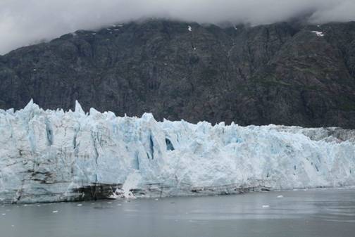
to Glacier Bay. Glacier Bay is a high point on any Alaska tour.
When discovered by Captain Vancouver in 1789, there was no bay, just
glacier. Now, 220 years later, there is almost no glacier and just
bay. It is a national park of great beauty and worth seeing. At the
mouth of the bay, we pick up two park rangers who will be our on board guides
and teachers. We travel some 40 miles up the bay to the Marjorie and
Pacific glaciers. The Pacific glacier has slowed and receded so much that
it looks just like the gravel moraine around it. The Marjorie glacier is more
active and travels 6 to 8 feet per day, calving chunks of ice several times an
hour. The face of the glacier is white and fractured in thousands of
places. Jagged shards of ice jut upward 50 feet. In places, the
clear blue of the heart of a glacier shines through. Every so often, a
crack sounds and some ice will slither down into the water. No giant
calves occur during our stay. With all the ice in the water of the
smaller variety, the ship is able to ease in quite close to the glacier and
Marilyn is able to spot a half dozen seals on an ice slab near the base of the
Pacific glacier. They can even see them without binoculars.
I search the slopes at the water’s edge. I scan the greens
on the hills. I just want to see some animal..…..
Bear, fox, dog, cat. Alas, nothing at all moves,
so my whole Alaska experience thus far has been seagulls. Jonathan
Livingston and his whole family take the Tahitian Princess as their rookery for
the stay. They perch on balconies everywhere. I am going to name
Alaska the “Seagull State.”
On the way out of Glacier Bay, we stop for a brief look at the
Johns Hopkins glacier from five miles away. We cannot go closer.
Ships are not permitted near the glacier because it is a locale where seals pup
and raise their young. We drop off the rangers late in the evening and
make our way toward Lynn Canal and the town of Skagway. The Lynn Canal is
a natural waterway of great beauty but winds ripping up and
down the straight canyon makes it treacherous to mariners. Alas,
we transit it during the night and nothing is visible.
Monday, 8/25/2008. We have traveled down to the Icy Strait
and then turned back up the Lynn Canal to Skagway. The fjord that
comprises the Lynn Canal is called a canal because it is straight and narrow,
with mountains on both sides falling nearly vertical. It is natural,
however.
At Skagway we rent a car and join with Judy and John to tour White
Pass and the headwaters of the Yukon River. The car is an aged Chevy
Lumina with 150,000 miles on it but it is strong and performs well. The
Sourdough Rental Company assures me that we won’t be charged for any dings, so
that is a plus. We travel up the valley leading to the White Pass
summit. This pass was opened when the White River & Yukon Railroad
was built during the Klondike gold rush in the last years of the 19th
century. The first prospectors had to travel by foot over the Chilkoot trail and pass to gain access to the Yukon and the
500 miles to the Klondike. The requirement to enter Canada was that each
man have a year’s worth of supplies. He had to
backpack these supplies (a half ton) to the border and then down to Lake
Bennett. Then he had to cut down trees and build a boat so he could
travel the lakes and rivers to the gold territory.
We have it a lot easier as we pass through customs and summit the
pass. On the other side is Lake Tutshi.
This glacial waterway is more than 15 miles long and fills a valley between
ridges. I am surprised at the sheer scale of this country. We stop
at the border between British Columbia and the Yukon Territory to get
pictures. We go on to Emerald Lake, which is bright green in color,
caused by the color of the glacial talc that lies on the bottom We stop
in the first nation village of Carcross, which is a
contraction of Caribou Crossing. This small town sits at the confluence
of Lake Bennett and Tutshi Lake and is the present
terminus of the White River & Yukon Railroad. (They have one
regularly scheduled train a day from Skagway to Carcross
and return. The paved highway continues another 100 miles to Whitehorse,
where it connects with the Alcan highway. This
makes Skagway the only coastal Alaskan town with inland connections.)
We return to Skagway and take the gravel road to Dyea, in the hopes of seeing some bears. Dyea was a twin town to Skagway, but had no deep water, so
the railroad went to Skagway and Dyea became a ghost
town. Alas, there is some kind of great hunt with dogs and baying and all
sorts of noise, so we see no bears. This is a spot to be very
careful. These are tidal flats, and 4-wheelers get stuck here. So I
very gingerly turn the car around and we go back to the ship. Somewhere
in Alaska we should be able so see a bear.
Tuesday, 8/26/2008. Today is a sea day, and our
first day in the open Pacific Sea out of the protection of the Inside
Passage. We make our way from Skagway to Valdez in quiet seas, with a
quite acceptable roll and pitch. We are shortly out of sight of land and
the rest of this leg is spent at sea. It is the first of three formal
nights, so we go to the captain’s cocktail party and then to dinner.
Wednesday, 8/27/2008. We arrive at Valdez early
in the morning. Valdez is located in beautiful Prince William
Sound. Everyone knows Valdez and Prince William Sound from the Exxon
Valdez accident. In march, 1989, the Exxon
Valdez veered out of the shipping channel to the northeast to avoid icebergs
from the Columbia Glacier. She went aground on Bligh Reef, spilling a
large quantity of crude oil and destroying a large quantity of sea life and
beauty of the area. Nobody was prepared for the spill, and hence it was
much worse than it could have been. Now, nearly 20 years later, there are
still negative effects.
Now, all oilers that visit Valdez must be double hulled.
Further, there are spill containment vessels on duty
in the sound at all times. Also, any tanker is required to have two big
tugs tethered to it all the time while maneuvering in the sound. Also,
the captain is required to be in command. (Since 9/11, there have been no
tours of the oil terminal.)
A short bus trip brings us to the Valdez Spirit, a tour boat that
will take us on a trip to the Columbia Glacier. This glacier is literally
self destructing. Bergs from the glacier completely block the arm leading
to the glacier and the nearest we can get is about 7 miles away. This is
close enough. The captain has to pick his way among the icebergs.
The Columbia Glacier ice extends over a thousand feet deep, so the only way you
can tell the age of the bergs is somewhat by the color. Pure crystalline
ice absorbs all color but blue, while newer granular ice is more
white. The older ice is brilliant blue.
It has always been a desire of mine to have a martini made with
glacial ice. This is not to be on this trip as I have eschewed alcohol,
but I will have the glacial ice. The deckhand nets a large chunk of
crystal clear ice weighing about 30 pounds. After all have had an
opportunity to get a picture holding the miniberg, I
chip off a piece and use it to chill my diet Pepsi. The ice is quite cold
and lasts an unusually long time. One glassful chills a can of Pepsi and
a couple of glasses of water. We see sea otters and orcas on this trip as
well. The boat is about 80 feet long and is 4 years old. It was
built in Bellingham Washington, and looks as though it
came down the ways yesterday.
After the boat trip, we get a brief tour of the town of
Valdez. This town has not yet been influenced greatly by the cruise ship
activity. It is typical small town America with a supermarket, a hardware
store, gas station, etc. Their one claim to fame is the quantity of snow
they get in winter. Several nice green playing fields in town are really
snow storage areas. They even have a nice display of their snow plows and
snow blowers.
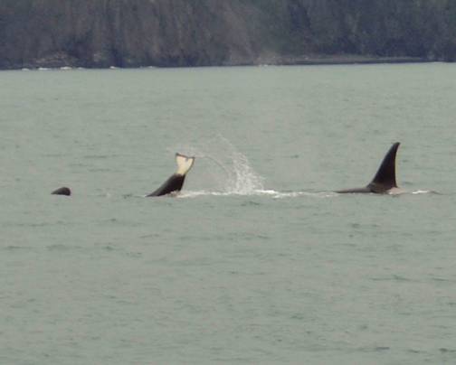
Thursday, 8/28/2008. Overnight, we travel the
short distance to Seward. Here we board another small boat to see the
sights in Resurrection Sound. Resurrection Sound was so named
because a Russian explorer who visited here on Easter thought it was a good
name. This trip starts with a 2-hour journey to see several pods of orcas
that have been sighted. It is a good sighting and soon we are near to
pods of 3 to 6 orcas. Their sharp black fins stand tall above the water
and occasionally they breach the water. It is a challenge to get pictures
of all this, but I manage several passable shots out of many.
On the way back, we cross over to the eastern side of the Sound
where the captain is able to nose the boat right in to within feet of the
vertical cliffs. The sights here are mainly puffins, but there are
several different sea birds nesting among the greenery on the cliffs.
Friday, 8/29/2008. We leave Seward in the
afternoon and travel across the Gulf of Alaska to Kodiak Island. Kodiak
is the home of the largest bears in the world, the Kodiak brown bear. I
have always marveled at the size of these bears. A fully mature male
(boar) will top 1500 pounds and stands over 11 feet tall on hind legs.
The females are smaller, but still weigh 1200 pounds. Alas, the only way
to view these beasts is to fly across Kodiak, across the Uyak
Bay to Geographic Bay in the Kodiak National Wildlife Refuge. This trip
takes most of a day and is prohibitively expensive. It also needs to be
arranged 3 to 6 months in advance and is, of course, dependent on the
weather.
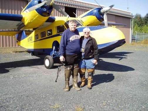
Notwithstanding all of the above, I decide to call and see if we
can get on a trip. The weather has been improving and promises to be very
nice for our one day in Kodiak. A call to Seahawk air tells me that they
are fully booked, but one of the other operators has had a cancellation and has
two seats available. We have 30 minutes to get down to the pier and be
picked up.
When we get to Harvey Air’s hangar, I see a Grumman Widgeon
sitting out front. My first question is, what
plane are we flying in? The Widgeon. All
Right! The Grumman Widgeon was used as a two engine seaplane in World War
II. It did everything from drop bombs to carrying personnel, but it was
mainly used for air sea rescue operations. The plane is nearly as old as
I am, but in much better condition. Without further fanfare, Marilyn and
I are issued hip boots and we are on our way. Marilyn and I, two brothers
from California, Jo, our naturalist, and the pilot are shoehorned in and off we
go. On the outbound trip, I get to ride in the copilot seat. It is
a real experience. Shortly we are flying over the green mountains of
Kodiak. It is strange to see vegetation as green as a golf fairway with
patches of white snow here and there. Once you leave the environs of
Kodiak, there are no roads, no tracks, not even any discernible paths. This is
really a pristine area. On the way, the naturalist points out several fin
whales
. 
The landing at Geographic Bay is spectacular, as the plane dips
down through a narrow land cut and settles quietly on the water.
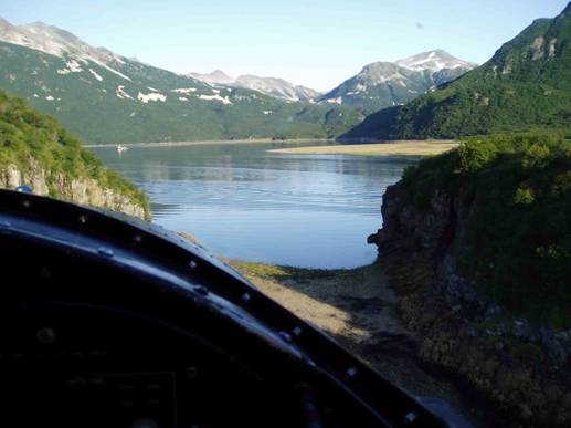
The pilot taxis in until the landing gear contacts the tidal
flat. We climb out into knee deep water and wade to the dry part of the
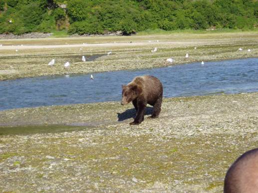
tidal flat. We can already see bears at a distance. Since we are
new to the whole activity, we have no idea what is supposed to happen
next. Needless to say, we are a bit scared and uptight.
Fortunately, the others in the group are also as new as we are. The group
from the other seaplane joins us and we are told to stay in a tight group and
to walk slowly toward the bears.
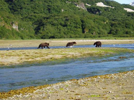
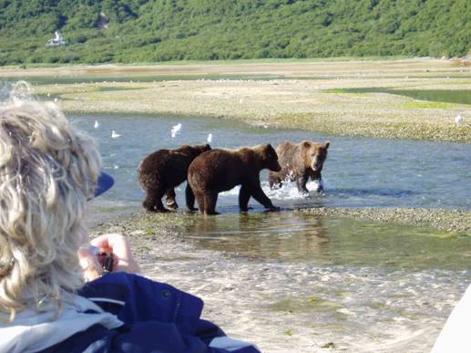
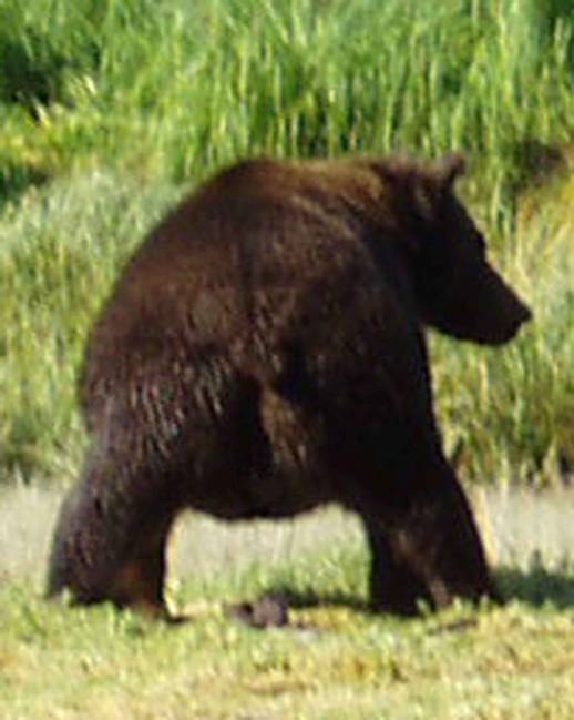
By now, there are five bears on the flats. One is a young
sow with two 3-year old male cubs. Now, male cubs in the game preserve
have a very poor life expectancy. The more established boars kill the
cubs to eliminate competition. A sow has to guard her cubs carefully or
they will be immediately killed. 3-year cubs have already learned to
fish, but they have also learned that it is easier to let mother catch the
fish, then move in to eat it. This is what is
happening on the tidal flats. A large boar comes toward the cubs, but the
sow immediately positions herself in front and after a complex process the boar
thinks better of the attack and ambles off to find some salmon. We keep
inching forward until no more than 30 feet separates us from the nearest
bear. The bears know we are there, but since we are no threat, they just
keep on catching salmon and eating. If one is passing, he or she will
give us a casual glance every so often, but no fixed attention. We sit in
a small group so as to make the group look less threatening. Who would
have thought that we would be sitting a few feet from feeding Kodiak bears?
The pilot keeps moving the plane closer in as the tidal flat
slowly disappears. Our viewing over, we walk back to
the plane. The water is a little deeper, and it nearly comes over
Marilyn’s boots. With a little help, we are back in the Widgeon and after
a splashy and exciting takeoff, Jo pulls out a huge lunch bag with sandwiches,
drinks, chips, etc. It is amusing to try to eat a roast beef sandwich
while your knees are interlocked with another person‘s. We dip low to get
some photos of a friend’s sailboat, take some pictures of a salmon seining
operation, try to find some mountain goats, and all too soon are back on the
ground at Kodiak. We left the boat at 8:00 am and are back aboard by 1:00
pm. We have about 60 pictures to document the trip.
Saturday, 8/30/2008. The day
dawns bright and clear. We are already some 250 miles east of
Kodiak on our way across the Gulf of Alaska to Juneau. We are
making 21 miles per hour and the seas are almost a dead calm. Ahead lies an overcast, and soon our warm sunny day is nothing but a
memory. Still, the sea is such that there is only the slightest roll
every half minute. For a body of water that can be nasty indeed, this is
an unexpected pleasantry.
Sunday, 8/31/2008. We arrive early in the
morning in Juneau, the state capitol. We have the third boat tour here,
so we hustle to the pier and get underway. This area specializes in
humpback whales, and they have lots of them. The humpback feeds by diving
down and taking in 5 or 10 thousand gallons of water. Then they surface
and cruise along the surface, expelling the water through the baleen in their
mouth. What remains is small fish, shrimp, and krill (a small shrimp like
crustacean). There is a small dorsal fin back near the whales tail (the
hump). When the whale starts to dive, this part comes out of he water for
a while, hence the name. The whale goes nearly vertical with the fin out
of the water, and then dives. So we saw this process over and over again.
Monday, 9/1/2008. It is an overnight trip to Sitka. Here,
the town has determined to keep the waterfront like it was, so cruise ships
anchor and tenders take passengers ashore. It is raining moderately, so
the trip is made in ponchos for the most part. Sitka has the inevitable
jewelry stores, but is sprinkled with an assortment of local stores as
well. Sitka was the capitol of the area when the Russians owned it.
As a result, it has a considerable Russian influence. There is a Russian
orthodox church here. It was here that the treaty ceding Alaska to the
United States was signed. (At a price of $.02
per acre.)
Tuesday, 9/2/2008. Today is a sea day.
We have departed Sitka and are on our way to Victoria, BC. Last night was
a rather rough night. With stabilizers, it wasn’t very bad. I
hardly noticed it. The roll period is so slow that it is nothing like a
rough night on the Amberjack. In any case, the captain said we had
20-foot seas. As the day goes on, the Pacific quiets down and by evening,
it is like a lake.
Wednesday, 9/3/2008. We arrive at Cape Flattery
at the mouth of the Strait of Juan de Fuca in a fog. Alas, I have always
wanted to see this body of water that leads to Puget Sound. The fog is
kind of patchy, so I do get a look. It is not very exciting, as the
strait is ten or twenty miles wide, so all you see are distant mountains.
We are part of the day transiting this strait, and by 3:00 pm, we are tied up
in Victoria.
We have no tour planned here, so we get off the ship and negotiate
with the cab drivers for a tour. The first guy wants $150 for two hours
in a vintage Bentley. The next wants half that for two hours in a Toyota,
so we go with him. He takes us through town and then on a long loop along
the shore. Victoria is known for its flowers, and in particular for
Bouchard Gardens, 15 miles north of the city. Despite the cabbie’s
warnings that we don’t have enough time to tour the gardens, we want to go
there. I figure a half hour will give us a feel for the place. But
when we arrive, we find that it would cost us $53 just to set foot in the
place. So we content ourselves with a look at the flowers at the entrance
and turn back to the city. We have negotiated a flat rate, but the meter
is running and is now at $110. The ride back is during rush hour, and by
the time we are at the dock, the meter is at $140. The cabbie starts the
song and dance that we have run over the two hours. To make a long story
short, we settle on $100. I was going to give him a tip anyway, so it
wasn’t too bad.
Thursday, 9/4/2008. We sail the short distance
between Victoria and Vancouver during the night. We must be ready to
leave the ship at 8:15 am. By 9:00 am we are in the van and headed out of
Vancouver. Just as a note, I rely heavily on the GPS to navigate in
strange cities. Here, I am among tall buildings and the GPS cannot see
the satellites and get a fix. It takes a while to find a place with clear
sky where I can stop and let the GPS do its thing. You know me, so
you can imagine the atmosphere in the truck during this period.
It was our plan to get a ferry from Vancouver to the San Juan
Islands, stay there for the night, then ferry over to
the Olympic peninsula of Washington state. Alas, there are no ferries
from Vancouver to the San Juans.
We pass through customs on the alternate truck route. The
customs officer asks the usual questions about where we went and why. He
then asks why we are driving such a large vehicle for just the two of us.
My mind is racing into whether they think we are smuggling. They will
want to search the van. It won’t be a problem, we have nothing illegal,
but it will take a lot of time. He then starts with “According to our
computers……” Oh, God, here it comes! “According to our computers,
you each gained eight pounds while you were gone… Have a nice day.”
We travel down on I-5 and then go about 20 miles west to
Anacortes, where we can get a ferry to the San Juans.
But when we get there, we find that we cannot get a ferry anywhere except to the
San Juans or back. There is no way to get to
the Olympic Peninsula from the San Juans. So we
drop the San Juans and decide to head over directly
from Keystone to Port Townsend. But you cannot get there from here.
You need a reservation to get on the ferry, and the earliest slot would be at
7:00 pm. I don’t want to go find a room at that hour. So we change
plans again. We get back on the I-5 and head south to Tacoma, below
Seattle. We get a room there, have a pizza delivered, and try to
recuperate from a very stressful day.
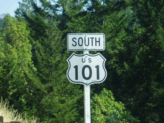
Friday, 9/5/2008. We start out on Rte
101. First we travel north along the Hood Canal, a natural waterway that branches off Puget Sound. This long narrow water
is very picturesque, but, alas, threatened by too much development. The waterway is huge but it only has a single
outlet at the end, so there is not very much circulation. Rte. 101 takes us along the Strait of Juan de
Fuca when we leave Hood Canal. Having
just transited the strait yesterday, we do not tarry here. 101 takes a turn inland and into the
mountains at Port Angeles and we stay with it.
We climb into Olympic National Park and pass Lake Crescent. The road is picturesque and winding (and 35
mph). I get stopped by a Park Ranger and
get a warning about my speed. 101
eventually turns south and drops down to the seacoast
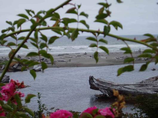
again for a short ways before going inland again to Aberdeen. While we are in Olympic National Park on the
seacoast, we find a rustic inn and restaurant for lunch. This gives me an opportunity to get some good
pictures of a nearby tidal pool.
Once past Gray’s Harbor and Willapa Bay,
we go back to the beach and cross the mighty Columbia River at Astoria.
We’re ready to call it quits for the night, but Astoria doesn’t
have much in the way of nice motor inns on the river. So we continue to the west to Hammond, where
again we cannot find a nice inn with a view.
We continue to Cannon Beach, which is a seaside resort and promises to
have some nice motels. After wandering
down streets so narrow that I have to back the van out, we find a lovely
Comfort Inn that has a large suite with a view.
The next morning I find that the view is of a pile of junk at the end of an old
marina, but there is a pretty lighthouse in the distance.
Saturday, 9/6/2008.
We get started down the coast and our first stop is Tillamook,
Oregon. You may have seen Tillamook on
cheeses at the supermarket. We go for
the self guided tour, but most of the plant is automated and inside mammoth
tanks and machines. It seems to be
running, but there is little to see. I
find that the machinery is separating the curds and whey. So I guess Little Miss Tuffet
was eating cheese… or was it milk? They
have a store, an ice cream counter, and a restaurant there, but it is swarming
with people, being a weekend. We leave
tourist central and find a nice local restaurant for an
nice lunch on local seafood.
We
stay with 101 down to Hebo, where we set off
east. The ride on Route 101 in
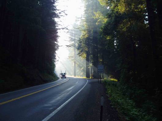
Washington and Oregon is just awesome.
One minute you are right along the beach, with tsunami evacuation signs
every 300 feet. The next minute, you are
at a thousand feet above the water, gazing tens of miles up or down the
coast. Regularly, you are plunged into nightlike depths in redwood forests where the floor has not
seen the sun for thousands of years.
The
road goes where it must in the forests, and eight foot tree trunks rise right
at the edge of the roadway. We visit
trees where you can drive through. There
are three of them in the area. They are
able to tunnel through a big tree because redwoods have no taproot. They just have a giant network of roots that
extend out hundreds of feet. But the van
is just a little too large to fit through, so we back it up in front of the tunnel
and take a picture from there.
At
Hebo, we leave Rte. 101 and take an easterly
route. My goal is to get to McMinnville,
where Howard Hughes’ wooden flying boat, the spruce goose, is on display. Route 22 is a severe driving test, winding
and rising and falling over the mountainous terrain. I am racing against time, for it is 4:00 pm
and most museums close at 5:00 pm. We
arrive at the museum at 4:35, and they do in fact close at 5:00. But they graciously allow me in until closing
time without charging me the $24 fee.
The
Spruce Goose is the largest airplane ever built. It is just awesome to stand near. The wingspan is over 300 feet, the length of
a football field. The hull is the size
of a small ship. The sponson
on the wing is almost as big as the Amberjack.
They allow you to climb stairs and enter the hull, but you are not
allowed up to the flight deck. There are
many other airplanes on display, and I take in as much as I can before they
throw me out.
Our original plan was to go back to the coast, go another 60 miles south, and then go east again to visit Debbie and Spenser in Eugene, Oregon. But that is a lot of driving for a little bit of seacoast, so we go south to Salem, get on I-5, and go to Eugene and get a room for the night.
Sunday, 9/7/2008. We find Debbie and Spenser Wagner in Eugene and have a pleasant visit with them in the morning. Then we head back to the coast and pick up Route 101 again. We pass the Oregon Dunes National Recreation Area without stopping and continue south. Without fanfare we cross the border into California. 101 has still more redwood forests and on we go through Eureka. But at a little town called Alton, south of Eureka, we must either turn east toward Sacramento or stay on 101 to San Francisco. So we leave the Pacific coast and travel Rte 36, then I-5 and around Sacramento on the I-80 bypass. I have no strong desire to actually tour the city of Sacramento, so we start the climb into the Sierras and stop for the night at Auburn.
Auburn was founded during the great California Gold rush when several men camped there for the night. While Auburn wasn’t a center for mining gold, it was in a perfect location for supplying and supporting the digging grounds, so a town grew up there. The old town is steeped in history.
Monday, 9/8/2008. We get off to the east and surmount famous Donner Pass. At Truckee we take Rte. 89 down to Tahoe City. We make a circle around Lake Tahoe. At Emerald Bay, we pass over the hairiest road I have seen yet. Rte. 89 travels out on a ridge that drops off to Emerald Bay on the north, and Cascade Lake on the South. The road travels right on a ridge and drops off steeply on either side. At least it is straight and flat. But then it loses altitude in a couple of switchbacks that are both unbelievably steep and tight. I have to crank the wheels almost to the stop to make the turn. And I would estimate the grade at 20 or 25 percent. I inquired of locals whether that road is open in the winter and was assured it is, but others have told me it is closed for weeks at a time.
We continue on our tour of the lake until we get to Rte. 50, which heads off toward Carson City. It is interesting that one never has to wonder just where the Nevada State Line is. Not to an inch do you need to wonder. The casinos start right at the line. We travel north through Carson City to Reno and rejoin I-80. We stop at Elko, Nevada for the night at the Red Lion Inn and Casino. I guess Elko has a height limitation, for the hotel is 3 floors high and a quarter mile long.
Tuesday, 9/9/2008. We’re in the home stretch now. We pass the Bonneville Salt Flats and the great Salt Lake and turn south to pick up I-70. Rte 6 offers a great shortcut, but there are electronic signs that warn us there will be long construction delays, so we stay with the interstates. We arrive in Dillon at 10:00 pm and the trip is over.